Before the Map App: How Bicycle Riders Found Their Way
Before map apps, bicycle navigation relied on paper maps, road signs, and local advice. See how riders combined these clues to plan and recover a route.
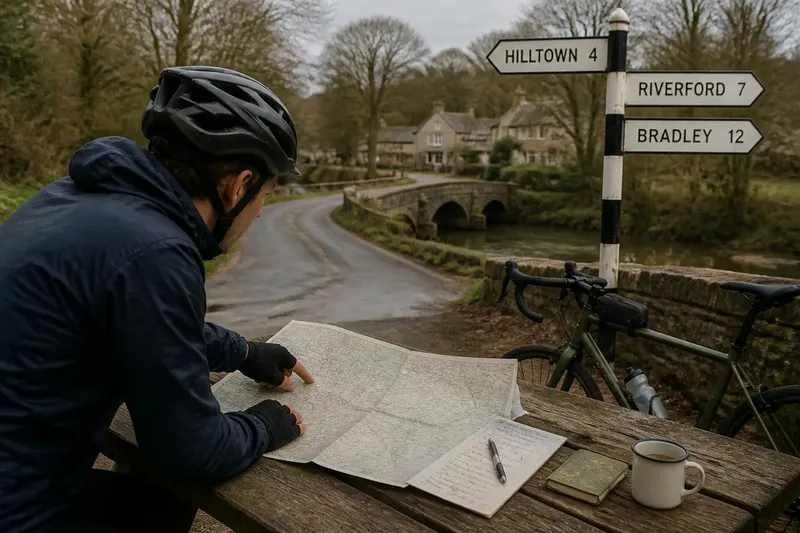
How did bicycle riders find a route before a phone could draw one? Bicycle navigation often began with a paper map at the kitchen table, continued with signs at junctions, and changed with advice from people who knew the roads. These methods shaped how riders planned, remembered, and adjusted a journey as it unfolded.
Maps at the table
Printed maps made it possible to plan a ride before setting out, but they asked a rider to interpret a landscape rather than follow a moving dot. Road maps showed connections and place names; local or regional maps could include smaller lanes, paths, and landmarks. The choice depended on the ride. A map designed for motorists might help with major roads yet leave a quiet lane or cycle path difficult to identify.
Planning began with a destination and a rough line between places. Riders looked for towns, rivers, railways, hills, and other features they could recognize on the ground. Those landmarks turned a flat page into a sequence of decisions: pass the market town, cross the river, then look for the road toward the next village.
Scale mattered, too. A broad regional map helped a rider see the overall direction, while a more detailed map helped with turns near a destination. Some riders carried both, or used a small overview map to plan and a larger-scale sheet for the tricky parts. A paper map is like a recipe: useful only if its symbols and instructions make sense to the person using it.
Signs at junctions
Road signs supplied information at the moment a choice had to be made. Direction signs named destinations and pointed along roads; warning signs and route markers offered other clues about what lay ahead. Their value depended on knowing which place names mattered. A rider heading toward a small settlement might need to follow signs for a larger town first, then watch for a local turn.
Signs also had limits. A destination could be missing from a sign, abbreviated, or shown as one of several names at a busy junction. In unfamiliar territory, a rider had to connect the sign with the map and the direction of travel. A sign was useful confirmation, not always a complete itinerary.
Cycle-specific signs, where present, could mark routes that were not obvious on a general road map. But marked routes did not necessarily take every rider to the desired place by the most direct line. Their usefulness depended on where they went, the kind of riding the person preferred, and whether the route connected with the wider journey.
Local knowledge in practice
People who lived or worked nearby often knew details a printed map could not convey well: a confusing fork, a road that felt unpleasant to ride, or a reliable landmark beside an otherwise unremarkable turn. Asking a shopkeeper, innkeeper, or another rider could turn a vague plan into a more legible sequence. The best directions often named both a turn and something to recognize when reaching it.
That knowledge was useful, but personal directions could be incomplete. “Take the next left” assumes the listener knows where the speaker is standing and what counts as next. A rider could ask for the road name, the destination shown on a sign, or a distinctive feature nearby. Repeating the instruction in their own words helped expose a misunderstanding before leaving.
Imagine a rider reaching a village with two roads toward the river. A passerby says to take the lane beside the old stone bridge, while the map shows a bridge symbol near the village edge. The rider compares the clue with the map, checks the river’s direction, and chooses the lane that fits both. The expected result is a decision supported by more than one clue, not a claim that every local direction is flawless.
When directions failed?
What if the map has no small road?
Check its scale and publication context before assuming the lane is absent from the landscape; a broad map may omit minor roads. Use nearby named places and physical features to orient yourself, then look for a more detailed local map or ask someone who knows the area.
Why do road signs seem inconsistent?
Signs may prioritize larger destinations, so a smaller place on your map can disappear from view for part of the journey. Follow a shared intermediate destination, then reassess at the next junction rather than expecting every sign to repeat the full route.
What should I do when local directions are vague?
Ask for a road name or a landmark at the turn, and request the name of the next place along the way. If those details do not fit your map, pause somewhere safe and ask again instead of guessing at a complicated junction.
How can I keep a paper map usable on a ride?
Mark the intended line lightly and fold the map so the current area is easy to reach. Keep it protected from rain and accessible without blocking your view or handling it while moving.
Carrying the route
A planned line on paper still had to travel with the rider. A folded map could sit in a pocket, bag, or map case; a larger sheet might be awkward to consult while riding. Riders commonly stopped in a safe place to check it, then memorized the next stretch. This separated route decisions from the business of controlling the bicycle.
Some riders made brief notes before leaving: a town name, a turn, and the next landmark. That could be easier to scan than a densely marked map, especially when the route crossed an area with many similar roads. Notes worked best as prompts, not as a substitute for understanding the general direction.
Memory played a practical role. A rider who understood the sequence of places could notice when the journey no longer made sense. If the plan was to reach a river crossing and the road continued away from the river, that mismatch was a reason to stop and reorient. The ability to pause and revise was part of navigation, not evidence that planning had failed.
Why the old methods linger
Digital navigation made route information easier to carry and update, but maps, signs, and conversation still offer useful ways to read a place. A paper map shows the wider network at once; a sign connects a junction to local destinations; a person can explain a confusing landmark. Each answers a different question, so combining them can make a route easier to understand than relying on a single clue.
That combination also changes the rider’s attention. Instead of following a line without context, a rider can notice how roads connect, where a river or ridge lies, and which places form the route’s sequence. The approach suits a leisurely ride as much as a practical trip, though anyone choosing a route should consider the roads and conditions they are comfortable riding.
Before map apps, bicycle navigation was a conversation between a rider, a page, the signs along the road, and people who knew the place. Even now, recovery is easier when you can name the next landmark and explain the direction you are heading. Before rolling on, keep one useful detail in mind: the next turn and what you expect to see after it.